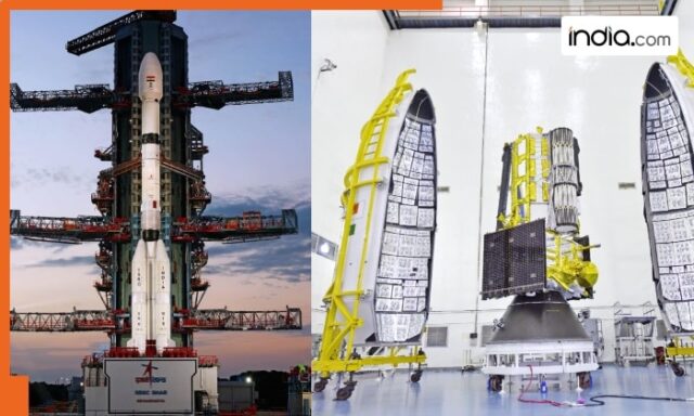
NISAR satellite is a combination of human skills and exchange of software and hardware between the two space agencies for over a decade.
NISAR, an acronym for NASA-ISRO Synthetic Aperture Radar satellite, weighing 2,393 kg is expected to fly on a 51.7 metre tall, three stage, GSLV-F16 rocket at a prefixed time of 5.40 pm from the second launch pad at this spaceport situated about 135 km from Chennai on Wednesday.
The countdown for the launch commenced at 2.10 pm on July 29 and has been progressing, ISRO said, and the mission would be classified into launch phase, deployment phase, commissioning phase and science phase.
The satellite would be able to study seasonal changes on forest dynamics, mountain shifts, glacier movements in the Himalayas and Antarctica, North and South poles.
What is NISAR’s primary objective?
NISAR mission’s primary objectives are to study land and ice deformation, land ecosystems, and oceanic regions in areas of common interest to the United States and Indian science communities.
ISRO said the complex payloads and mainframe systems in the mission have been designed, developed, and realised over a period of 8 to 10 years.
Scientists from both space agencies were involved in extensive collaborations and the NISAR satellite carries dual frequency — two L Band provided by NASA and S-Band provided by ISRO for the Synthetic Aperture Radar (SAR) enabling the collection of a vast amount of data.
The S-Band SAR and L-Band SAR were independently developed, integrated and tested at ISRO and Jet Propulsion Laboratory, NASA, United States, respectively, ISRO said.
After reaching the initial orbital conditions on Wednesday, scientists would engage in ‘commissioning’ the satellite.
What all has been developed by ISRO?
The spacecraft and the launch system are developed by ISRO while the L-band Radar system, high speed downlink system, GPS receiver are delivered by NASA. ISRO is responsible for the satellite and commanding operations, while NASA would provide the orbit manoeuver and RADAR operations plan.
NISAR mission would be aided with ground station support of both the two space agencies for downloading the acquired images, which, after the necessary processing, would be disseminated to the user community.
GSLV-F16 is the 18th flight of Geosynchronous Satellite Launch Vehicle and the 12th with indigenous cryogenic stage. It is also the 102nd launch from Sriharikota.


